This blogger’s agrees with Mr. O’Toole’s comment about Frank Lloyd Wright in a previous blog at this web site. This architect is truly unique and in an elite class of visionary thinkers of all time. The proliferation of his works takes a back seat to no one. The blogger’s reference to his name and other design professionals of previous generations was to show a mild comparison with the current generation of New Urbanists and others. The latter group are far from “do nothings” and have made significant contributions to the field of planning. At a recent planning conference about two years ago, the speaker of one the presentations happened to be a fellow graduate of the Yale University of Architecture with the likes of Duany and Soloman. The presenter relayed a story about one of the his professors who basically called these future New Urbanists “slouches” and that they would fail to accomplish much in the field.
With regards to Mr. O’Toole’s comments on Herbert Gans’s writings, his works somewhat underlie a theory of similarity in our society and its resultant transformation over time whether in an urban area or suburban setting. Whether this is influenced by the forced urban renewal of Boston’s West End or the creation of Levitt’s suburban development in New Jersey maybe moot.
This blogger is somewhat familiar with both locations. With regards to the West End, his father-in-law’s business had to be relocated to another city neighborhood closer to the inner ring suburbs. Many of the same customs and traditions that were practiced in the West End were repeated in his new location in Brighton.
With regards to the second community, this blogger recently viewed the sister community of Levittown, New York out on Long Island. This blogger did not recognize anything out of the ordinary with the surroundings other than the noted names of places within the community. Over time, the enormity of this tract development has blended into the fabric of Long Island. Today, Levittown, New York does not demonstrate any unique advantages or disadvantages of suburban communities.
The concept of community has uniformly changed over time. For many people on the go there is limited interaction with neighbors whether in the city or suburb. In many ways, one could make the argument that the suburban communities may have edge on community cohesiveness. For example, in the third tier suburban community where this blogger works, there is a heightened level of volunteer involvement, while in the blogger’s home community there is more of a resignation that “you can’t fight City Hall.”
Friday, April 6, 2007
Thursday, April 5, 2007
Random Thoughts

This blogger has completed ten blogging entries which included an introductory statement, planning staff organizations, genealogy and planning, a travelogue, European contributions, terminology explanations, and other matters. Since this is an evolving work, there are gaps in the presentation. This blog will hopefully try to plug up a few of the holes in order to pursue better suburban planning results. (Picture cited on the web at www.bsu.edu/classes/ruch/msa/tansey.html.)
Howard Kunstler decries about the places of today which are currently masquerading as livable units; however in reality they are indistinguishable from each other with “everyplace is like no place in particular, where the city is a dead zone and the countryside a wasteland of cars and blacktop.” (Cited in Kunstler’s Geography of Nowhere, jacket page.) . Our goal will be to establish practices to avoid these cookie cutter approaches and yet be environmentally, socially, and economically sound.
Laura Miller from the University of California at San Diego notes “the suburban ideal is about finding a homogeneous community of like-minded people, about living in a home which provides comfort and diversion, and quite centrally, about finding an environment in which family ties can be strengthened.: Although the geography of suburbia promotes togetherness, it does so at a cost of suburban sprawl which “has done away with the site for socializing.” Consequently there is a decided lack of public spaces –sidewalks, squares, taverns, central shopping districts, etc.—where non-family members gather” which further isolates the suburbs and breaks down the integration of the community. (Cited in Laura Miller’s paper entitled “Family Fun in the Suburbs: Family Togetherness and the Suburban Ideal”, pages 1-41.)
This blogger has noticed from personal observations that not only are each suburban community surrounded by an “invisible moat” but so are many of the residential homes. This way of life and individual mind set will be difficult to change. As a child, this blogger remembers playing a lot of impromptu sports, today everything is organized with a rigid schedule. The Days of Solitaire are here unless you are a part of the rigid organizational environment.


What can be done? First, one needs to foster a new sense of togetherness and place by creating sustainability. Two, mixed use development needs to be encouraged so that people can have access to a range of facilities and options for walking to goods and services.; three, to create a sense of place that is interwoven like a piece of fabric with various patches of material in a unique pattern; four, incorporate trends in telecommunications, home occupations, decentralized businesses, and other aspects of cyberspace; five, minimize the environmental problems caused by trash disposal, air and water pollution; six manage the use of our natural resources by using hybrid vehicles, green buildings, recycling programs, and stormwater management techniques.(Pictures cited on the web at ---http//www.terrain.org/articles/13/superbia.htm. Picture on the left depicts:"The transition to Superbia! might include clustered parking to save space and get cars out of peoples' way; greater use of solar energy; community gardens; and a Common House, cooperatively owned by neighbors.")
Sustainability and Smart Growth
Definitions of Smart Growth
Smart Growth has a number of varied meanings and regional modifications throughout the country. One definition cited on the Smart Growth America web site at http://www.smartgrowthamerica.org/whatissg.html defines smart growth “according to its outcomes —outcomes that mirror the basic values of most Americans. Smart growth is growth that helps to achieve these six goals: 1. Neighborhood Livability…2. Better Access, Less Traffic…3 Thriving Cities, Suburbs and Towns…4. Shared Benefits…5.Lower Costs, Lower Taxes…6. Keeping Open Space Open.”
The Encarta dictionary web site at http://encarta.msn.com/dictionary_1861707929/smart_growth.html defines
smart growth as “sensible growth: economic growth that consciously seeks to avoid wastefulness and damage to the environment and communities.”
On the west coast, San Diego’s Association of Governments (SANDAG) web site at http://www.lisc.org/san_diego/assets/asset_upload_file873_6802.pdf defines
smart growth as “compact, efficient, and environmentally sensitive pattern of development that provides people with additional travel, housing, and employment choices by focusing future growth away from rural areas and closer to
existing and planned job centers and public facilities.”
On the east coast, the New Jersey Department of Community Affairs on their web site at http://www.nj.gov/dca/osg/smart/index.shtml defines smart growth as “well-planned, well-managed growth that adds new homes and creates new jobs, while preserving open space, farmland, and environmental resources. Smart Growth supports livable neighborhoods with a variety of housing types, price ranges and multi-modal forms of transportation. Smart Growth is an approach to land-use planning that targets the State’s resources and funding in ways that enhance the quality of life for residents in New Jersey. "
"Smart Growth principles include mixed-use development, walkable town centers and neighborhoods, mass transit accessibility, sustainable economic and social development and preserved green space. Smart Growth can be seen all around us: it is evident in larger cities such as Elizabeth and Jersey City; in smaller towns like Red Bank and Hoboken, and in the rural communities like Chesterfield and Hope." (Cited on the web page for the N.J. Dept. of Community Affairs.)
"In New Jersey, Smart Growth supports development and redevelopment in recognized Centers—a compact form of development—as outlined in the State Development and Redevelopment Plan, with existing infrastructure that serves the economy, the community and the environment.” (Cited on the web page for the N.J. Dept. of Community Affairs.)
In Massachusetts, Smart Growth is defined as “Well-planned development that protects open space and farmland, revitalizes communities, keeps housing affordable and provides more transportation choices. This is cited at the State’s web site-- http://www.mass.gov/envir/smart_growth_toolkit/pages/glossary.html#smartgrowth
Massachusetts Smart growth legislation, further elaborates on smart growth definition by describing it as a principle of land development that emphasizes mixing land uses, increases the availability of affordable housing by creating a range of housing opportunities in neighborhoods, takes advantage of compact design, fosters distinctive and attractive communities, preserves open space, farmland, natural beauty and critical environmental areas, strengthens existing communities, provides a variety of transportation choices, makes development decisions predictable, fair and cost effective and encourages community and stakeholder collaboration in development A smart growth zoning district shall provide for residential usage “to permit a mix of housing such as for families, individuals, persons with special needs, or the elderly.” Said housing would be allowable for a proposed density [of] at least “20 units per acre for multi-family housing, 8 units per acre for single-family homes, and 12 units per acre for 2 and 3 family buildings.” (Cited at http://www.mass.gov/dhcd/components/SCP/ch40r/statute.pdf.)
Definitions of Sustainable Development
Like smart growth there are a number of sustainable development definitions. The following is a sampling of those descriptions.
In 1987, The World Commission on Environment and Development defined sustainable development as that “which meets the needs of the present generation without compromising the ability of future generations to meet their own needs. “ (Cited in the report by Kevin Krizek and Joe Power entitled “A Planners Guide to Sustainable Development", page 55.)
Sustainable development is also defined as the “the ability of a community to utilize its natural, human, and technological resources to ensure that all embers of present and future generations can attain a high degree of health and well being, economic security, and a say in shaping their future while maintaining the integrity of the ecological systems on which all life and production depends.” (Cited on page 56 of the “Guide to Sustainable Development”.)
Further, flourishing communities are the foundation of a healthy society. Communities must strive for sustainable development. “Sustainable development implies adaptation and improvements in a context in which communities seek to protect natural processes and landscape function, and to conserve resources for future development.” (Cited in the "APA Journal ", Summer of 1996, page 332.)
A holistic approach to planning and design is stated in The Ahwahnee principles:” Sustainable communities are cities and towns that prosper because people work together to produce a high quality of life that they want to sustain and constantly improve…Businesses, households, and government make efficient use of land, energy, and other resources… with minimal waste and environmental dame. [There is] efficient use of existing infrastructure, energy, water, materials, and land. ..Sustainable community design is based on an understanding of the powerful effect of the built environment on aesthetics, scale and a sense of history and culture…All planning should be in the form of complete and integrated communities containing housing, shops, work places, park and civic facilities essential to the daily life of the residents. (Ahwahnee principles are described on the web at the Local Government Commission web site at http://www.lgc.org/ahwahnee/principles.html.)
Sustainability and Local Planning
Timothy Beatley states that “creating sustainable communities …is a matter considering ecological limits and environmental impacts at every aspect of community design… [including] how the industrial and commercial sectors go about their business.” (Cited on page 17 of the “Guide to Sustainable Development".)
This blogger prefers to strive for sustainability rather than smart growth. Some would argue they are one and the same. To this blogger, the concept of sustainable development is more positive than a judgmental use of the term “smart growth”. In Massachusetts, if the density does not meet the required thresholds does it then become “dumb growth”?
Horizontal growth as described in the term “sprawl” is not necessarily inherently evil, what is needed is a boost in implementing livable community techniques towards sustainability. To start sustainable development needs a new way of thinking that includes: one embraces a future time horizon that is long term and does not necessarily rely on short term gains and the bottom line; two, identifies carrying capacity limits; three, approaches planning in a “natural and geographic” depiction rather than political units; four, recognizes “areas of planning (transportation, housing, and economic development, etc.) not as end in themselves, but rather as a means to an end [with ] end being a sustainable community”; five, pursues a holistic and interconnected approach to planning and identifying multi-faceted impacts; six, involves the citizenry in the pursuit of these objectives. (Cited on pages 18-21 of the “Guide to Sustainable Development")
Future blogs will further illustrate the concept of sustainable development and positive designs for suburbs. The end goal is to produce quality communities with modern conveniences that fend for themselves just as the shtetls and classical communities did in the past.
From Shtetl to Suburia: A Personal History and Its Relationship to Planning

The study of genealogy is a study of one’s ancestral heritage. In the mid 1970’s, Alex Haley made this popular with his work entitled “Roots”. Our family history is interrelated to the events and cultures of human civilizations throughout time. The study of genealogy can give one a sense of involvement and participation in these events for a particular period. Genealogy gives us a sense of personal meaning within the larger society. Where we live, how we clothe and shelter ourselves is essential to our lives as we know it. The blogger’s family odyssey begins in Eastern Europe and currently continues in the United States and other countries. (Picture cited in "The Shtetl Book" by Diane and David Roskies, page 13.)
Origins in Eastern Europe
The earliest time that this blogger can trace back his roots is the early 1700’s in Eastern Europe. To be more precise our ancestral family came from the modern day countries of Latvia, Lithuania, and Belarus. This area has a multi-cultural and religious history. For example, over time there have been a number of ethnic and territorial influences including groups ranging from the Visigoths, Swedes, Hungarians, Jews, Russians, Poles, Germans, Belarusians, Ukrainians, and others.
On the blogger’s wife’s side, her family came from the urban settlement of Vilnius, today’s capital of Lithuania. Even the city’s name and spelling changes depending on which inhabitant ethnic group you are identifying. To the Belarusian’s it was “Vil’nia, to the Lithuanians it was “Vilnius”, to the Poles it was “Wilno”, to the Russians it was Vil’na, and to the Jews it was “Vilne”. Until WWII, Vilnius was a cultural center for the Jewish populations. Those that lived in Vilnius were considered part of the urban elite or “Berliners”.
Many of the blogger’s ancestral family originally came from more rural roots and they were labeled “Karliners”. The blogger’s great, great, great, great-grandparents were situated in an area of the Ukraine and Belarus known as Polesia which was traversed by the Pripet River and the Oginsky Canal. This geographic location was characterized by extensive marshlands and forests. Settlements occurred both in villages or mirs such as the community of Motol and Telekany, along with larger market towns such as Kobrin and Pinsk. Key economic and social characteristics included the timber industry, agriculture with oaks, barley and potatoes, and fishing. With communication and travel limited until the advent of the railroad, each village was self-sustaining in producing “virtually all the necessary products from bast shoes to furniture and houses.(Cited in Yehuda Reinhartz’s book entitled “Chaim Weizmann: The Making of a Zionist Leader”, page 4).
The ancestral home of the blogger’s family was constructed of wood with a primitive heating system in the center of the home and a roof made of straw. Their house was in the midst of the village, yet they had a few animals such as cows and chickens. It should be pointed out that the blogger’s ancestral family along with others could not own land. This is critical to the blogger’s grandparents who strived to own their property in the United States.
Some of the blogger’s distant relatives and community inhabitants, known as landmen, worked for the Polish nobility on their large estates such as the Radziwells. In their case it was the Polish Count Skirmunt on his family’s extensive landholding near Pinsk and Motol and one of these relatives was one the administrators of this estate. Near the time the blogger’s grand-parents moved to this country, many relatives moved to the larger community of Pinsk. Pinsk is a marketplace community that originated in 1506. Nearby there was an adjacent community known as Karlin, which was established in 1751. This latter community expanded and laterally grew outward towards the boundaries of Pinsk. Eventually the two communities merged however for several years each kept their own identity until probably WWII. Karlin was “considered on the right side of the tracks” and “the intelligentsia, wealthy industrialists, and worthies made their home there.” (Cited in “Chaim Weizmann, “The Making of a Zionist Leader", page 20.) . This blogger’s great uncle owned a tanning factory in Pinsk which by today’s environmental standards would need major modifications. This family along with others were liquidated by the Nazis in World War II. The blogger’s grandparents and parents were able to sponsor one of this relative’s sons to immigrate to the United States. The mere fact that this blogger’s family owned property on a farm was extremely helpful for sponsoring them to enter this country.
Before leaving the origin section of this blog, it should be pointed that different ethnic groups lived separate neighborhoods within these communities. Jews and gentiles had limited contact with each other, the term “ghetto” had its origins in Eastern Europe particularly with advent of pogroms and the Nazi influences.
Short Stays/Pit Stops
Manchester, England
In the early twentieth century, many of the blogger’s relatives, came to the United States via passage through England. The blogger’s grandfather spent at least six months in Manchester, England . At the end of the 18th century, Manchester became was one of the first industrialized cities of the Western Civilization. Manchester was the home of cotton textile manufacturing and was one of the largest concentrations of said manufacturing in Great Britain. Manchester itself was a community of uncontrolled expansion and played a key role in the industrial revolution. Besides the factories, there were large warehouses built to store the yarn and finished cloth. Houses were closely packed together next to factories all over the city. Housing conditions were terrible as noted in the following writings by Friedrich Engels: “one penetrates into this chaos of one-storied, one roomed huts, in most of which there is no artificial floor; kitchen, living and sleeping room all in one…Everywhere before the doors refuse and offal…this [was a] whole collection of cattle-sheds for human beings “. Cited on the web at http://www.fordham.edu/halsall/mod/1844engels.html.
Over time conditions improved in this city. Reformers worked to improve the living conditions for workers in subsequent Industrial villages; yet the physical layout is somewhat modeled in Industrial villages such as Lowell, Massachusetts and Pullman, Illinois.
Bristol, Connecticut
This blogger’s grandfather immigrated to the United States in the early 1900’s and ended up in Bristol, Connecticut. At this location he worked as a painter, with his brother, and met his wife. Bristol, Connecticut has a population of approximately 60,000 inhabitants and is a manufacturing town that was particularly known for its clock making industry which dated back to 1790. In addition there was other manufacturing in machinery, electrical equipment, and metal products. Currently it is the home to the ESPN television network and the nation’s oldest continually operating amusement park..
Worcester, Massachusetts –first time
This blogger’s fraternal grandparents lived several years in this city on what was known as the “East Side.” Worcester is a city of 154,000 inhabitants and is also an industrial center with multitude of manufacturing establishments that manufacture abrasives, machinery, ceramics, and other items. A section of the city where the blogger’s father was born went through a period of urban renewal in the 1950’s to 1960’s that included the construction of a major expressway cutting right through established ethnic neighborhoods. Around 1920, The blogger’s grand parents eventually moved after saving up enough to buy a farm in Spencer, Massachusetts.
Three/Four Decades of Farming in Spencer
There was one big family on the farm which included the blogger’s grandfather’s brother, sister, and her children as well as his children and wife. Said farm was located in a valley location among a number of hills. This farm was over three miles from the center of the community of Spencer. This town was noted for textile and wire manufacturing. The population of this community is around 12,000 inhabitants and its noted for three things: one, the home of the sewer machine and truss bridge inventors; two, the home of the Trappist monastery known as St. Joseph’s Abbey; three, a yearly agricultural fair that occurs over Labor Day weekend.
The blogger’s family carried out dairy farming with some crop production. However, adult members of the family did not get along. Eventually there was a split with the blogger’s grandparents and their children moving to another farm nearby at a hillside location. This site did not lend itself to crop production and eventually the operation was transformed to a poultry farm. As for the original farming site, the remaining relatives moved out to another farm in Charlton, Mass. Where the first farm was extensive with a large house that included a spiral staircase, the Charlton farm was more primitive in scope. At some point in time both were eventually bought out by the Trappist Monks, who established the their abbey on extensive land holdings of over 1,000 acres.
According to Thomas Merton, in his book entitled “ The Silent Life”, “a monk is a man of god.” Said man has been called upon by the Holy Spirit to relinquish the cares, desires,and ambitions of other men.”(Cited on page vii.) Most monks within the monastery are “expected to have their fair share of digging in the garden, pitching hay, chopping wood, peeling potatoes, washing dishes and sweeping floors.”(Cited on page 31) The most important aspects of monastic life, are “silence, solitude, recollection, and prayer.” At the St. Joseph's Abbey, the Cistercian life “is basically simple and austere.. It is truly poor and penitential.. It is through stability that we commit ourselves to this community [and] it lives in an atmosphere of silence and separation from the world which fosters and expresses its openness to god in contemplation.”(Cited in Merton’s booklet entitled “Cistercian Life”, page nn). The “monastic buildings, and the things that are made and use there, are so beautiful…The purity of taste in a monastery…flows…from the purity of heart.” (Cited on page 29 in “The Silent Life”.)
Worcester 2nd time around and Suburbia
In the 1960’s the blogger’s parents and their children moved to Worcester. This time a simple 1950’s ranch style home was purchased on the “West Side” of the Community. It was in a suburban type location yet included urban amenities such as bus service and nearby stores and other commercial uses within in walking distance. This simple ranch style house was a major downsizing from the extensive farmhouse situated on 60 acres of land to a small lot of 7,000 sq ft lot. Other relatives also moved onto other suburban locations throughout the United States in areas that required at least two automobiles to move about for work and other activities.
Tuesday, April 3, 2007
European Planning Influences on Third-Tier Suburbs: Installment One
Very Very Quick Historical Overview
Ancient Planning: Greece and the Roman Empire
The concept of the “city-polis” was “probably consciously created as early as the seventh century B.C. The city is some form of partnership where people strive together to live in a place for the highest good. According to Aristotle man is a political animal by nature and inhabits cities which are formed from several households and villages combining to become complete and self-sufficient. Cited on the web at http://www.uni-rostock.de/fakult/philfak/fkw/iph/strobach/demo/pol/Lecture%203.pdf.
Ancient Greek planning is dominated by architecture in the form of great edifices that have survived till recent times particularly the agoras, palaces, and temples. These monumental structures have formed the genesis of a number of planning movements including the City Beautiful initiative and New Urbanism. (Cited in A.E.J. Morris’s book entitled “History of Urban Form”, pages 35-54.)
As for the Romans, this society organized their Empire into “a state where cities and countryside could be regarded as two facets of one and the same culture.” Monumental structures and forms also predominated the landscape as well. Key architectural and planning elements included paved streets, courthouses, circuses, houses, libraries, and public baths. The forum was the public square or marketplace in the city which served as the “administrative, commercial, and economic center of the colony, [and] was a lively place of economic, cultural, and artistic exchanges.” The Romans emphasized the importance of cities and transformed a number of existing villages into cities as well. (Cited in “History of Urban Form”, pages 55-91.)
Medieval Planning
After the collapse of the Western Roman Empire, the Church influenced human settlement. “Medieval society was centered on the Church. The church was responsible for housing for the poor and encouraging commerce, building and the arts. For example, markets were held under its walls and religious buildings became the focal point of education and worship. The medieval towns developed around religious buildings and were created “with a sense of order and continuity.” A regular form of settlement was devised with a cluster around a castle, church, or natural eminence. Wall fortifications were built around these communities to protect the inhabitants “from the hostile barbarian countryside without.” By the 14th Century, the French turn “suburbe” was used based on the Latin term of “suburbium which was defined as two parts: “sub” meaning near and “urbs” meaning city.(Cited in “History of Urban Form”, pages 92-156.)
Renaissance/ Baroque City Planning
During this period the concepts of the ideal city centered on the circle or square with star shaped fortifications and a central core. Also new emphasis was placed on aesthetics. The ideal city was “expressive of a longing for utopia… [where] man imposed his own ideals of order and heroic dimensions.” Manheim, Germany in the 1600’s, Versailles, France, and Karlsruhe, Germany are good examples of the Renaissance/Baroque Planning. Both Karlsruhe and Mannheim “evolved around the palaces and great gardens of the royalty.” (Cited in Gallion and Eisner, “The Urban Pattern”, pages 49-50.)
According to Lewis Mumford in his book entitled “The City in History” the “city proper itself was transformed into “a sector of the original spider web, with the other avenues radiating out into a park or the open country.” For example, the royal town of Karlsruhe evolved into a pattern of a “partial star.” (Cited in City in History, pages 390-392.)
Western Europe—Versailles France and Andre Le Notre
Of special note was the development of Versailles. In 1624, Louis XIII purchased land near the small village of Versailles and built a royal hunting box. Over time, this site transformed into the grandest palace with the village becoming the “suburban capital” of the country. The monarch’s son hired Andre Le Notre to create a vast park from the earlier gardens. This park was described as “a great vista flanked by two shrubberies and following the central axis of the palace, with symmetrical arrangements of lawns and flowers on either side of this line.” (Cited in the History of Urban Form, pages 210-213.) According to Gallion and Eisner in their book entitled “The Urban Pattern”, the gardens of Versailles…was space of unparalleled proportions, scale of incomprehensive size. Here was the concept of a man…set about to become master of nature.” (Cited on page 49.)
Of additional note is the town of Versailles itself with “its combination of approach radials, to the glory of the monarch, and an expediency surveyor’s grid.” (Cited in “History of Urban Form”, pages 21.) All main avenues would lead to the palace. According to Mumford, the palace…would close the vista. The axial approach served as a spotlight to focus attention on the prince.” (Cited in “The City in History”, page 389.) Later in time, this “radial motif” played a key role in the design of Washington, D.C. by Pierre L’Enfant.
Industrial Revolution and Pre-Modern Planning—Paris France—Baron Haussman
The pre-modern period is the two hundred year period between 1700 and 1900 where Western Civilization was transforming from an agrarian society to an industrial society. With the invention of the railway and steam engine, the country side began to transform itself. Land allocated for different purposes to achieve maximum economic efficiency. Construction of tenement housing was profitable and standards for land uses were lax. Slums were created and issues of public health and safety were at stake.
By the mid 1800’s, Napoleon III recognized these conditions and was concerned with potential mob violence. With one eye open to control this, the emperor proposed a program to create broad avenues through the slums. Baron Georges-Eugene Haussman was selected to administer this program. Haussman laid out “new streets in long sweeps cutting through the maze of medieval lanes.” He created many grand boulevards by “radiating avenues” from the Place de l’Etoile and Champ Elysees across the open fields. Paris experienced rapid growth into its suburbs and “absorbed the open spaces” where there were pre-existing walls. (Cited in “The Urban Pattern”, pages 83-85.)
Modern Planning
The modern period is identified from the turn of the twentieth century to the current times of the twenty-first century. There are a number of modernist planners and architects who will be discussed in a future blog. The rest of this blog will comment on areas that are not publicized as much as Western Europe.
Central Europe: Austria—Vienna and Camillo Sitte
Vienna was typical of the medieval form of settlement. There was a clear demarcation between the town and countryside. In 1857 the old fortification system was demolished and in its place was constructed a broad tree lined avenue known as the Ring. Land use within the built-up area of the city was characterized by mixed uses with tenements, warehouses, and factories.
One of the most influential European architects and planners was Camillo Sitte who was born and died in Vienna. In 1883, his book entitled “City Planning According to Artistic Principles” enunciated basic principles of urban design. Sitte considered the proportions of town squares, monuments, and churches. Planning should be “creative art.” The interplay between public buildings and open spaces was paramount to good planning. He considered the gridiron subdivisions as “monotonous” and maximizing “land exploitation. Vienna was cited as one of the communities that practiced some of these principles. (Cited in Arnold Whittick, ed., “Encyclopedia of Urban Planning”, pages 902-903.)
In 1905, a prohibition of construction within a “woods and meadow” belt around the city was implemented by municipal law. Planning after 1955, finally considered combining elements of urban design, transportation planning as well as traditional land use zoning. One theory of town extension schemes would incorporate old villages and existing settlements as “suburbs” with good public transport and incorporate them with some of the surrounding countryside rather than leap into more isolated open stretches of land. Next, an urban renewal concept in suburban districts would encourage redesigned suburban centers with apartments replacing existing subsistence settlements. (Cited in “Encyclopedia of Urban Planning”, pages 134-148).
Eastern Europe: Poland
In the early eighth to thirteen centuries, settlement characteristics consisting of
“constructing the first of the grody (fortified burghs) around which the additional settlements-military, working-class, and commercial suburbs—clustered. By the fifteenth century, the urban network for a number of Polish towns was firmly established. However, many Polish communities were devastated by the activity of World War II. The historic core of Warsaw was basically leveled by the Nazis. In an extraordinary achievement, this city’s houses, churches, and other buildings were rebuilt in their historic form. In more recent times, existing towns have been developed in new districts and housing projects. In the period between 1950 and 1955, twenty five “new towns were built or major extensions carried out.” Some their town centers would accommodate central services and urban amenities with housing and its associated service facilities. (Cited in “Encyclopedia of Urban Planning”, pages 829-842).
Sunday, April 1, 2007
Social Welfare Planning

In the book entitled "Urban Planning and Social Policy”, the editors, Bernard J. Frieden and Robert Morris stressed the need to remold physical and social planning together. These two planners, along with others including Melvin Webber and Martin Rein, decried the splitting of these two areas of interest into distinct categories since WWI. To these individuals it became apparent, that there was a necessary “interrelationship between several criteria: “a decent modern environment includes not only physical comfort and work, but education, services, and social relationships which open opportunity for all.” Further physical planning stresses the “proficiency in zoning, land use, and traffic patterns” is not sufficient to “establish the urban environment”; while “social forces are not powerful enough either.” Thus city planning and social planning need to converge “in the scope of action for which they call in the comprehensiveness of their views, and in their common stress upon spreading urban benefits to all the population.” (Cited on pages 2 and 3). Next, according to Melvin Webber, planners must assist to “extend access to opportunity” …“integrate larger wholes”, and :”expand freedom in a pluralistic society.”(Cited on pages 11-22).
According to Morris and Rein, the assessment of “our theoretical framework for planning in social welfare is long overdue.” These two further stress “the importance of a local community deserves special comment. Voluntary agency planning flourished in the belief that local communities constitute the essential foundation of American society.” Social welfare planning has been grounded in four major aspects: one, the “federated character as typified by local welfare planning councils; two, “the organized expression of a belief in rational utopianism”; three, the devotion of “their energies to problems which grew out of distribution and redistribution of resources among agencies, clients, personnel functions, and funds”; four, the strategy of consensus seeking.”(Cited on pages 23-28. ) (As an aside this blogger will comment on utopianism in a future entry.)
With the downsizing of the Great Society programs” , government sponsored social policy has been limited. In the heyday of the Johnson Administration, programs such as Model Cities and Appalachian initiatives were instrumental in the well being of significant segments of population. In addition, urban renewal forced the need to study socio-economic impacts and address the needs of those relocated by such physical changes upon the landscape.
Today, social welfare planning is centered on Faith Based Programs taken on by a number of religious organizations. The remnants of the pre-existing social welfare planning initiatives are the concentrated efforts by these groups within their respective communities to maintain a level of service for the homeless, welfare assisted individuals, and other poverty segments of the population. At that same time, the social fabric of the community i s changing with the decline of bowling clubs, scouting, and other social clubs which have negatively affected the sense of belonging within the communities. (Cited in Robert D. Putnam's book entitled "Bowling Alone: America's Declining Social Capital.")
The planners have somewhat neglected social welfare planning. A case point is the report entitled "Planning for an Aging Society" by Deborah Howe and others. In this report, “little attention is given to various issues that have a bearing on the needs of the older people including homelessness, relocation of substandard mobile homes, recreation planning, and rural economic decline.” In addition “broader social issues such as the viability of the Social Security system, the need for retirement planning, funding of health care, and long term care insurance” are not discussed at all despite the impacts on the growing number of elderly. According to these authors “an understanding of the demographic changes and a commitment to addressing locally specific needs…is one step toward toward facing these issues with a positive, creative, and effective planning approach.” (Cited on 6.)
Finally, in a recent report entitled "Planning Active Communities" edited by Marya Morris, planners and public health advocates are creating a new alliance to examine the “relationships between land-use planning, health, and physical activity in plans” Yet these are somewhat limited in assisting the individual at perhaps the expense of the common wealth. In the suburbs these issues are paramount particularly with the aging population unable to afford the homes they live in.
Saturday, March 31, 2007
Travels with Kerli Q: First Installment
This blog will deviate from the previous blogs somewhat to describe this blogger's recent trip to the New York area. Yesterday, this blogger had an opportunity to spend some time exploring a number of settlements in Connecticut and New York. The blogger did not take one of the quicker routes and instead opted for a more leisurely journey utilizing the Long Island ferry.
Kelo
 Since there was an hour’s worth of free time prior to boarding the ferry boat, the blogger had the opportunity to visit portions of the waterfront area of New London. This shoreline community re-ceived a lot of publicity due to the recent landmark land use court case in the Supreme Court. The notable case of Kelo vs. City of New London is intriguing on a number of levels with reference to eminent domain taking of land. As a municipal planner involved in redevelopment, this case had a number of implications for future development in existing built up "grayfield" areas in suburia.

New London is a small port city of 25,671 inhabitants. Its history is rich with traditions, customs, and notable events. In the recent past, the economy of the area was greatly influenced by the defense related establishments that were involved in submarine development. Today, the emphasis has switched to more involvement in the tourist related industry including two large gambling resort establishments less than twenty minutes away along with high tech and office centers.
Kelo
 Since there was an hour’s worth of free time prior to boarding the ferry boat, the blogger had the opportunity to visit portions of the waterfront area of New London. This shoreline community re-ceived a lot of publicity due to the recent landmark land use court case in the Supreme Court. The notable case of Kelo vs. City of New London is intriguing on a number of levels with reference to eminent domain taking of land. As a municipal planner involved in redevelopment, this case had a number of implications for future development in existing built up "grayfield" areas in suburia.
New London is a small port city of 25,671 inhabitants. Its history is rich with traditions, customs, and notable events. In the recent past, the economy of the area was greatly influenced by the defense related establishments that were involved in submarine development. Today, the emphasis has switched to more involvement in the tourist related industry including two large gambling resort establishments less than twenty minutes away along with high tech and office centers.
The city is attempting to improve its waterfront and adjacent areas as exemplified in the above picture. The question becomes whether eminent domain taking for economic development purposes was totally proper. The concept of urban renewal utilizing eminent domain taking conjures up of massive destruction of existing neighborhoods and the forced relocation of its inhabitants. The example of the demise of the West End of Boston is an infamous example of the social destruction of a neighborhood. Many of Jane Jacobs ideals were based on the need to need to preserve great cities such as New York from these catastrophes. On a suburban level, the implementation of eminent domain would be considered an “urban evil” and an anathema to the ideals of suburban living. The challenge will be changing this established process to possibly a more humane approach and yet accomplish the greater goal of improving the well being of the community by stimulating economic development .
 The Elusive Butterfly
Upon landing on Long Island, it was this blogger's goal to find a rail transit stop area that epitomized proper land use development and intensity. The elusive butterfly was not caught on this trip. Starting of the end of the main line on Long Island, this blogger visited a number of sites and could not find a site that matched the scale and mix of development that would be an example for third tier suburban communities. A pleasant by-product of the trip was listening to two Long Island radio stations, one of which announced individual resident birth days while the other station was characterized by a talk show that discussed future development around one the below noted rail stops with a local government official.
Many planners talk about density of population around transit stops. Their mantra is "critical mass, critical mass, critical mass." Not one of them fully understands the implications of imposing a very high density of population in housing of over twenty dwelling units per acre in a community that has existing levels of .5 to 5 units per acre. Changes of this nature are considered earth shattering by many of these inhabitants and an affront to their well-being.

The blogger’s first stop was Greenport, New York. This community of 2,048 inhabitants is situated adjacent to the water and has a number of amenities including a picturesque downtown and a ferry boat connection to Shelter Island to its south.

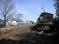
The second stop along this Long Island Railroad line was Southold, New York. Southold has a population of 20,599. Its station has very limited parking any automated ticket machines. As you can see in the picture on the right, the appearance of the land uses was far from optimal.
The third stop was Mattituck, New York.  Mattituck has a population of 4,198. It has
  a very nice compact downtown which is integrated with the rail station. The train stop is set next to a historic period center center with gas light and brick sidewalks. The scale is pedestrian oriented and of all the sites visited, this site comes closest to matching the goals of the blogger in terms of a model suburban train stop. The two pictures below depict the connection of train stop and downtown area.


 Mattituck has a population of 4,198. It has
  a very nice compact downtown which is integrated with the rail station. The train stop is set next to a historic period center center with gas light and brick sidewalks. The scale is pedestrian oriented and of all the sites visited, this site comes closest to matching the goals of the blogger in terms of a model suburban train stop. The two pictures below depict the connection of train stop and downtown area.

Proceeding inland, the next stop was Riverhead, New York. Riverhead has a population of 27,680 and is characterized by its ethnic population, country government buildings, and its large outlet mall. The train station was notable and the station was situated near the downtown and the government buildings.

My next to last stop was Medford, New York. Medford has a population of 21,985. This community was less traditional than the other stops. The stop was somewhat difficult to access off the arterial roadway yet was was adjacent to a number of non-pedestrian oriented businesses. Of note was the sheltered station depicted in the picture.

The last stop was Central Islip. This stop was located in a community of 31,950. It is surrounded by intense one story development. This station is typical large regional park and ride stop with few amenities.
At this point, the blogger stopped examining other rail stations. On a positive note, many of the small stations had a well integrated system of intermodal linkages including buses, jitneys, automobiles, and pedestrian connections.
Rural Contributions to Third Tier Suburbs

In a previous blog, this blogger mentioned the loyal followers of either the classical urban setting or the natural pastoral landscape. This blog will mainly describe the rural viewpoint and its relationship to the suburbs particularly the third tier settlements. In the mid 19th Century, a group of landscape painters known as the Hudson River School of Landscape Painters depicted idyllic view of the landscape. A good illustration of this pastoral depiction is the above picture entitled “Cider Making in the Country.”
A number of writers, planning individuals, and other visionaries elaborated on these visual depictions such as the noted transcendentalist Ralph Waldo Emerson in his writing entitled “Nature” and Edward Hale in his writing entitled “Sybaris and Other Homes.” Hale stressed his vision of settlement as stated in the following: “all along now were houses, each with is pretty garden of perhaps an acre, no fences… [said] houses were of one story…this was a mere suburban habitat.” (Cited on page 33.) The actual communities of Litchfield, Connecticut and Concord, Massachusetts epitomized many of these ideals spelled out by these two writers.
Ebenezer Howard refined these ideals in his concept of the Garden City. This was followed by the outstanding work of Frederick Law Olmsted and others. In the classic “The Anglo –American Suburb” edited by famed architect Robert A.M. Stern, there is a direct reference to Olmstead and Calvert Vaux who designed Riverside, Illinois. Riverside was considered a prototype “suburban village” and followed “the principle that a suburban community could be planned as a unit and would retain its identity…protected by greenbelts, gates and other barriers. (Cited on page 24.)
At this point, it is necessary to further explain the concept of “village.” The use of the term “village” may also be misapplied to various planning type discussions. There are suburban villages, rural villages (as previously noted), urban villages, industrial villages, craftsman’s village, and political entities known incorporated villages. These phrases deserve further clarification. The classic historic village is a community set in a countryside setting. Examples of this are depicted in the document entitled “Hamlets of the Adirondacks: A Manual of Development Strategies”. Here, the local villages and hamlets “are unique physically and culturally” in terms of “landscape setting, history, people, spaces, buildings and districts.” (Cited on page 6.)
In an article in the May/June 1992 issue of Utne Reader, entitled “Rediscovering the Village” by Robert Gerloff, a more urbanized village is defined as “a compact gathering of houses, apartment buildings, corner groceries, Main Street shops and offices. A village is friendly to pedestrians, a place where you can easily walk to work or to the grocery.” Page 94) “It is also a community of diverse individuals and families.” (Cited on page 96.)
An industrial village s described the article entitled “Industrial Village Communities in the United States by John Nolan. (Cited in Garden Cities and Town Planning, 1921, vol 11 no 1, pages 6-9.) Indian Hill in Worcester, Massachusetts was considered an industrial village.
Said village must be “town planned”, must have no more than 12 houses per acre, must have social amenities including open spaces, must reserve the natural features of the community, and should have co-operative or public ownership of the site.
The Craftsman’s Village is designed “for living, working, and marketing, all in your own tri-level condominium unit. It is a haven for artists and trades folk who want to live simply and independently while going about their work and promoting their creative products” in shops that are small and the shopkeepers are friendly. An example of this is located in Oak Creek Wisconsin on four aces of “suburban-rural land next to a wooded area and a lake.” (Cited in promotional material on this village.)
The political term village is defined by the various states. For example, in New York, “a village is a general purpose municipal corporation formed voluntarily by the residents of an area in one or more town to provide municipal services.” There are 574 of these villages in the state which range in size from 50 to 50,000 in population. In Nassau County, Long Island several of these village are closer to the upper limits in population. (Cited from unreferenced sources.)
Getting back to the discussion on the rural influence of settlement patterns upon the suburban landscape, several new prototypes evolved after Riverside. Many of these communities were established in the outer edges of metropolitan areas. Two good examples are Radburn, New Jersey, and Greeenbelt, Maryland. Radburn was “conceived” by Clarence Stein as a “town for the motor age.” Radburn was “a combination of ideas derived from the Garden Suburb tradition with new strategies developed to deal…with the automobile.” Among its characteristics included the freestanding single family home with garage. (Cited in Anglo-American Suburb, page 84.) Other elements included: one, the superblock; two, specialized roads built for “one use”; three, “complete separation of pedestrian and automobile; four, “houses turned around …facing gardens and parks”; five, “park as backbone of the neighborhood.” (Cited on pages 41-44, “Toward New Towns for America” by C.S. Stein.)
The origination of the Greenbelt towns was initiated by the two Federal Acts: one, the Emergency Relief Appropriation Act and two, the National Recovery Act in 1925. President Hoover then established the Resettlement Administration and appointed Guy Tugwell as Director. Under Tugwell’s influence the Federal government became interested in the production of new towns. Greenbelt towns were experiments in combining the Garden City ideal, the rRadburn idea, and the neighborhood unit together. Greenbelt, Maryland, which is located on the outer fringes of both Washington and Baltimore, became one of these communities. Key elements of this Greenbelt community included the walking system, underpasses, individual gardens, the use of open spaces, the shopping center and the “related community center” and the integration of the development with the natural features of the site particularly its development on the curved plateau utilizing a crescent roadway network. (Cited in Stein, pages 136-150.)
In the past seventy years or so, other communities have evolved such as the post war and “sit com” suburbs. The main stay automobile suburb blossomed into production after World War II due to two major underlying factors: one, the Federal government creating new mortgage instrument which made the purchase of single family homes more attractive; two, the major improvements in the highway system which made connectivity between the urban fringe areas and the central city easily accessible by automobile.
A good example, of the post-war suburb are the Levittown settlements created on the fringes of Philadelphia and New York which were characterized by long superblocks dominated by mass produced single family homes, long and wide streets, and pod type developments with little integration of land uses. (Cited in the book entitled “Yard, Street, Park” by Girling and Helphand, page 82.) These type of suburbs were labeled “sprawl” by many in the planning field, despite their unique positive qualities of providing affordable housing to large segment of the population.
In 1969, Ian McHarg’s classic work entitled “Design with Nature” was published which added a more holistic approach to physical planning on the landscape. New “greenfield” type developments would be designed utilizing an overlay method analyzing the various natural features such as hillsides, wetlands, and soils. This was exemplified in his conceptual plans for Staten Island which at the time was considered a suburb of Manhattan.
This was further refined by the concept of open space development design that was popularized by Yaro, Arendt, and others in the book entitled “Dealing with Change in the Connecticut River Valley.” For example, the community of Hadley, Massachusetts which is located on the far outer edge of the Springfield metropolitan area, was studied for potential development by depicting “net usable land area” by deducting floodplains, wetlands, steep slopes…publicly owned lands, and parcels protected by permanent conservation easements” from the total land mass in the community. More creative developments were illustrated in concentrated locations that preserved the unique natural features and scenic vistas of the community. (Cited in “Rural by Design” by Randall Arendt, page 250.)
A more livable form of development for suburbs has evolved that pursues “an environmentally sensitive sustainable lifestyle. (Cited in “Yard, Street Park” page 173.) Good examples of these “ecoburbs” are the communities of Woodlands in Texas and Village Homes in Davis, California.
The former settlement is indicative of the expansive “Greenfield” development of master-planned communities, while the latter is much more modest in scale. In the Village Homes concept, the open space design has been further refined to utilize the open space in a more productive manner including harvesting home grown crops.
The rural contribution to the development of third tier suburbs will evolve further as time marches on. The need for renewable sources of energy will create situations that will make these third tier suburbs more self-sustaining and refocus community concepts within its citizenry.
Wednesday, March 28, 2007
A Toothache Critique of Planning Buzzwords

First of all this blogger wishes to apologize to the great thinkers of our time, for the interpretation of the following buzzwords: community, neighborhood, smart growth, and new urbanism. This blogger recognizes the outstanding contribution from these architects, planners, allied professionals, and commentators including but not limited to Andres Duany, Elizabeth Plater-Zyberk, Peter Calthorpe, Daniel Soloman, Shelly Poticha, Sim Van der Ryn, Philip Langdon, James Howard Kunstler, Michael Corbett, Robert Cervero, Hank Dittmar, Randall Arendt, and others. These individuals collectively are part of a historical movement for town and city planning that are equal to the likes of Frank Lloyd Wright, Le Corbusier, Daniel Burnham, Louis H. Sullivan, Ebenezer Howard, Camillo Sitte, and others.
The first key word misused is the term “community.” Community means different things to different people at various spatial levels. John Winthrop, the first governor of Massachusetts stated in 1630 “Consider that wee shall be as a City [community] upon a Hill, the eies of all people are upon us.”. President Ronald Regan inferred upon the entire country (community) as that “shining city upon a hill.” The President spoke of a “tall proud city built on rocks stronger than oceans…teeming with people of all kinds living in harmony and peace…and if there had to be city walls, the walls had doors and the doors were open to anyone with the will and heart to get here.”
The first key word misused is the term “community.” Community means different things to different people at various spatial levels. John Winthrop, the first governor of Massachusetts stated in 1630 “Consider that wee shall be as a City [community] upon a Hill, the eies of all people are upon us.”. President Ronald Regan inferred upon the entire country (community) as that “shining city upon a hill.” The President spoke of a “tall proud city built on rocks stronger than oceans…teeming with people of all kinds living in harmony and peace…and if there had to be city walls, the walls had doors and the doors were open to anyone with the will and heart to get here.”
Robert Nisbet states that community “goes far beyond mere local community.” It “encompasses all forms of relationships which are characterized by a high degree of personal intimacy, emotional dept, moral commitment, social cohesion, and continuity in time. Community is founded on man conceived in his wholeness…it achieves its fulfillment in a submergence of individual will that is not possible in unions of mere convenience or rational assent. (Cited on page 2, The Search for Community in Modern America, edited by E. Digby Baltzell.)
Further, “community is the product of people working together on problems, of autonomous and collective fulfillment of internal objectives, and of the experience of living under codes of authority which have been set by…persons involved.” (Cited on page xvi, The Quest for Community by Robert Nisbet.
Nesbit decries the “suburban horde” because there are “no common problems, functions, and authority.” He states that community “thrives on self-help..[people]come together to do something that cannot not be easily be done in individual isolation.” (Ibid)
Many considered suburbs a pejorative term below the standards and dignity of city and countryside communities. Others feel that these suburban communities are being undermined by a number of forces including apathy, subversion of power, family breakdowns, technology, work ethic, and host of other influences.
In 1991, a number of the above referenced individuals got together and created a series of community concepts known as the Ahwahnee Principles. These community principles help “define a community where housing and all the things needed to meet the daily needs of residents are located within walking distance of one another. They call for returning population densities around transit stops to provide a critical mass of people and activities in these areas needed to make transit economically viable.”
Many of these individuals helped organize a movement in planning known as “New Urbanism.”
One of the key principles of new urbanists is the concept of neighborhood as defined by Clarence Perry in his writings cited in the Regional Survey of New York and Its Environs dated 1929 (Cited in the Practice of Local Government Planning, 2nd edition, page 42). There were several key parts to the neighborhood unit principle: one, an elementary school at its center; two, an easy walking distance to that school; three, elongated blocks with no through traffic within the blocks and commercial uses on their perimeter; four, the area be owner occupied single family detached homes with backyard playgrounds.
This neighborhood concept evolved into more modern adaptations including the “transit
planning area” which is characterized by a walk time corresponding “to approximately ¼ mile to ½ mile” with an area ranging from 125 acres to 500 acres. According to some, this area has to have a critical mass of population.
In the State of Massachusetts, there is growth management legislation entitled “Smart Growth Zoning and Housing Production”, under General Laws Chapter 40R. Under this law, “smart growth” is defined as having a “housing density in the proposed [zoning] district …of at least 20 units per acre for multi-family housing on the developable land …8 units per acre for single family homes…and 12 units per acre for 2 and 3 family buildings.”
This blogger happens to live in an established urban neighborhood in a central city with nearby shopping and elementary schools. Yet my neighborhood would not meet Perry’s definition today nor would it meet the density requirements of Chapter 40R.. The elementary school may be within walking distance, but school zoning districts and school choice allow children to attend schools other than those geographically closer. Also many of the house lots in the neighborhood are bigger than 7,000 sq.ft. and therefore would not meet these density thresholds.
Basically, the new urbanists and smart growth advocates in Massachusetts have defined an urban type model for future development in these zoning districts. Many third tier suburbs can not absorb that Kind of density. The implications on schools and infrastructure in the respective communities are staggering. In the suburb of Ashland, Massachusetts, there is two hundred acre site that is being “master-planned” as a transit friendly development near an existing railroad line; however the parcel of land exclusively dedicated to multi-family development does not have the density required to meet these requirements in the state legislation. Said density is only 17 units per acre despite the project size of 500 units on the site. In other words, does this project qualify as “Dumb Growth” since it does not meet these design thresholds?
To briefly sum up, this blogger has issues with the definitions and application of many of the concepts elaborated in this blog. It is time to adapt new terminology and implementation techniques to meet the demands of these third tier communities and other growth centers.
Tuesday, March 27, 2007
Planning Organization in Third Tier Suburbs-Second Installment
In the first installment on “Planning Organization in Third Tier Suburbs”, this blogger described a staffing comparison of eighty-five communities. What was neglected or not clearly specified, in the first installment, was the connection between staffing levels and the workloads, responsibilities, and formal functions of the individual planning offices.
The staffing level of a particular department does not necessarily coincide with the individual planner workloads and responsibilities within that community. To back up this comment, this blogger will mention an anecdotal story about a town planner in a first or second tier suburb in Central Massachusetts. In observing this planner, it appeared that he had a lot of dead time. In order to make himself appear to be busy, he assisted the town administration in answering phones and meeting with the general public on non-related planning issues, other free time was used to study for an additional advanced degree. His planning work load, therefore, was significantly dependent upon the limited activity of new development within the community in terms of both subdivisions and commercial site developments.
The staffing level of a particular department does not necessarily coincide with the individual planner workloads and responsibilities within that community. To back up this comment, this blogger will mention an anecdotal story about a town planner in a first or second tier suburb in Central Massachusetts. In observing this planner, it appeared that he had a lot of dead time. In order to make himself appear to be busy, he assisted the town administration in answering phones and meeting with the general public on non-related planning issues, other free time was used to study for an additional advanced degree. His planning work load, therefore, was significantly dependent upon the limited activity of new development within the
 community in terms of both subdivisions and commercial site developments.
 On the other hand, in this blogger’s community, there are times where a customer needs to take a ticket in order to stay in the queue for a response to their questions by the Town Planner. It is these times that the Town Planner pulls his hair out.
The above instances highlight the need to study a generic job description for a Town Planner and compare it to individual positions of Town Planners in other representative communities.
Generic job descriptions of Planning positions are available from the Local Government Institute in Tacoma, Washington. Eight key highlights of a generic job description for Town Planner are as follows.
One, “supervises the development and implementation of growth management, land use, economic development…or other plans and codes.” Administers “community development programs and services pursuant to adopted rules, regulations, and budgets.”
Two, “supervises the evaluation of land use proposals for conformity to established
Plans and ordinances; and evaluate proposal development impacts.
Three, oversees enforcement of local codes where applicable.
Four, oversees the permitting functions of developments including application, fee
Assessment, plan review, inspection, and occupancy.
Five, provides staff support to the Planning Board and other boards as needed and assigned. Also serves as a member of various task forces and committees.
Six, prepares and writes grant applications including maps and plans.
Seven, “develops and maintains a data base of information for planning.”
Eight, “monitors inter-governmental decisions and legislation actions.”
This generic job description has a different emphasis in more mature communities such as in first or second tier suburbs. For example, there are a number of communities that are heavily involved in redevelopment activities. In many instances these communities administer the Community Development Block Grant program. For example, the community of Greenfield runs a CDBG program which includes its downtown and surrounding residential neighborhoods. Its planning staff spends considerably less time on subdivision type issues. In the blogger's working community, a time allocation study was conducted several years ago and it was determined that over 44% of the planner's time was spent on developer type tasks including subidivisions, commercial developments, and land platting.
It should be pointed out that there are three categories of communities that benefit from CDBG funds in the State of Massachusetts: one, entitlement communities that are guaranteed funding directly from the Federal government; two, min-entitlement communities that are guaranteed funding through the state based on meeting the national objectives; three, discretionary communities that are selected in a highly competitive basis as determined from an elaborate scoring system set up by the state.
In other words, discretionary communities can not rely on obtaining these funds on a yearly basis and should not anticipate these funds for their respective planning activities. Many communities such as an Ashland or Hopkinton are considered relative wealthy communities by CBDG standards and therefore should not waste their time applying for these funds.
Other deviations from the generic job description include items such as supervision of engineering consultants and attendance at numerous committee meetings. In the former case, communities such as Blackstone Southborough and Fox borough use independent consultant companies for peer reviews and on-site inspections. In the latter case, the organizational structure of the community and the lack of professional staff create situations for increased volunteer efforts administering government functions at evening meetings that require the planner’s attendance.
Sunday, March 25, 2007
Planning Organization in Third Tier Suburbs-First Installment
In a recent post on Cyburbia, Vagaplanner referred to a one-person department as possibly having too much influence. He was concerned with being a “’one man show’ when it comes to making recommendations on new development and planning related issues within the community.” It got this blogger thinking about one man departments including who they report to, responsibilities, workloads, and formal functions. This blog is the first of series of comments on one person departments and will primarily deal with the staffing of such a department.
In the third tier suburbs, the staffing of a planning office is essential in the successful implementation of land use controls and land use planning. In Massachusetts, the size of a community sometimes dictates the amount of staffing for planning functions. For example, the City of Worcester with a population of over 172, 000 (2000 Census) had over forty planners in both municipal staffing positions including the Office of Planning and Community Development, Bureau of Land Use Control, Informational Systems and GIS operations office, along with quasi independent agencies such as the Housing Authority, Redevelopment Authority, and Community Development Corporations. In the meantime a third tier suburb such as Ashland, Massachusetts (which is this blogger’s working community) has a population of 14,674 (2000 census) with only one planner on staff. In a large staffing situation, planning functions are segmented out to various staff members, while the one person staff has to be a jack of all trades.
There are 351 incorporated communities in Massachusetts; however the organizational structures of these local government units vary depending on their communities home rule charter. For example, the Town of Brookline which is an inner ring suburb of Boston has a population of 57,107 (2000 Census). This community is basically totally build-out with very few areas primed for “greenfield development.” At the same time, the City of Leominster which as a population of 41,303 (2000 Census), still has a number of “greenfield sites” available for development. Nevertheless, the staffing for the two separate planning departments are relatively similar in size; however, the organizational structure of the community has a bearing on which items are prioritized and completed for implementation procedures. In Brookline there are bi-annual town meeting votes while the City Council in Leominster meet on a bi-weekly basis. For example, zoning amendments and map changes can occur throughout the year in Leominster , while in Brookline the timing of these actions are much more limited in scope.
A few years ago, this blogger worked on a staff comparison of 85 of the 351 communities in the state. This study utilized the Massachusetts State Department of Education’s categorization of the “Kind of Community” for comparison purposes. The community categorization were based on seven sub-classes of communities: one, economically developed suburbs; two, growth communities; three, residential suburbs; four, rural economic centers, five, urban centers; six, retirement/artisan areas; seven, small rural communities.
Of the 85 communities studied, forty two were economically developed suburbs, eighteen were residential suburbs, twelve were rural economic centers, eleven were growth centers, one was a urbanized center, and one was a small rural community. Population ranged from 3,939 (1999 esimate) in Boylston, a residential suburb, to a high of 66,910(1999 estimate) in Framingham, an economically developed suburb. Of these eighty-five communities fifty seven had a Town Planner on staff. The information on the remaining communities was somewhat lacking, however these communities may rely on volunteers and other assigned from regional planning agencies. Also many of these communities had additional staff in allied positions including Conservation Agents, Town Engineers, Assistant Planners, and GIS professionals. Twenty two communities had Conservation Agents, twenty-eight communities had a Town Engineer, and thirty other communities had staff planners or technicians in GIS. Some of these communities doubled up functions such as the Community of Oxford which has its Town Engineer serving as Town Planner as well.
Twenty two communities were examined in more detail for their respective planning activities.
Where there was available data, the category of subdivision plans including cluster developments and frontage lot developments (ANRS in Massachusetts) ranged from a low of three to a high of fifty-four. Next, the category of processing commercial site plans ranged from a low of four to a high of nineteen. Three contiguous communities of Ashland, Holliston, and Hopkinton had subdivision activity totaling 73 items, while only two communities outside of the Interstate 495 belt area had that much activity. As for zoning changes, these same three contiguous communities had thirty-six zoning amendments and map changes. Only a few other communities within this study group matched these types of activities, namely Middleton, and Tewksbury for zoning changes, and Charlton, Oxford, and Sudbury for subdivision activity.
Looking at the staffing levels of these three communities: one community namely Holliston had a Building Inspector who served in a dual capacity for a short times as the Town Engineer. The other two towns had no Town Engineer. All three had one person planning staffs and each had allied assistance with a Conservation Agent.
Six towns, which were all located in the Metro West section of metropolitan Boston, were examined in terms of reporting authority by the planning staff. Of the six towns, the Town Planner reported to the Town Manager in only one town, in all other communities the Town Planner reported directly to the elected Planning Board of that community.
In summation, the amount of staffing has a direct relationship on the workload of the Planning Office. If a community is growing or has a lot of development activity, this planner will be extremely busy in his or her workload.
Saturday, March 24, 2007
Mission Statement for Suburban Planning Blog
This is the initial post of this blog. The mission of this blog is multi-faceted. One, suburban planning represents a particular challenge. Many planners and others wax over the greatness of city places and rural retreats. Suburbia offers its own unique challenges. Suburban locations need to create their own niche upon the landscape. Suburban areas can be differentiated by their respective location near city centers and their respective age of their individual municipalities. This blog shall concentrate on the "third tier" suburbs which are not mature suburbs nor are they located near the central cities. These suburbs also are not necessarily exurban communities on the edge of the metropolitan fringe that characterized by large tracts of vacant lands primed for greenfield development.
Two, local government staffing for suburban planning is generally limited in its personnel and organizational set ups. One person shops are typical and will be interesting to cite reports on this subject. Three, many planning oriented individuals have spoken on the concept of new urbanism, transit oriented development, and sustainable development. How these different concepts work in suburban settings will be critical to the understanding of current and future planning. Four, this blog will not be limited to North American examples but will explore European Planning and its impact on the landscape of the United States. Five, this blog will also examine social planning. Physical planning is important; however striving for a sense of community is essential for well being of these suburban locations. In this category, the blog includes the need for planning for handicapped and special need populations within the second and third tier suburbs. In the recent past, efforts have been made to concentrate programs and activities for special needs populations in central cities and mature inner ring suburbs.
Two, local government staffing for suburban planning is generally limited in its personnel and organizational set ups. One person shops are typical and will be interesting to cite reports on this subject. Three, many planning oriented individuals have spoken on the concept of new urbanism, transit oriented development, and sustainable development. How these different concepts work in suburban settings will be critical to the understanding of current and future planning. Four, this blog will not be limited to North American examples but will explore European Planning and its impact on the landscape of the United States. Five, this blog will also examine social planning. Physical planning is important; however striving for a sense of community is essential for well being of these suburban locations. In this category, the blog includes the need for planning for handicapped and special need populations within the second and third tier suburbs. In the recent past, efforts have been made to concentrate programs and activities for special needs populations in central cities and mature inner ring suburbs.
Subscribe to:
Posts (Atom)